Jeanne Newby
Throughout the years, the names of Webb City streets have been changed. Once that change is made, it is usually put out of mind, never to be thought of again! Here is a reminder of where the streets were located and their names.
It seems only appropriate that the City of Webb City would have a street named in honor of the founder John C. Webb. Webb Street runs north from Fourth Street. At the time it was platted, the street ran in front of the Webb Home at 110 N. Webb St. To the north of Webb’s Home was John Street, also named in his behalf. But it was renamed Austin Street in 1922.
Other streets throughout the city have been named in honor of certain people of distinction. Tom Street was named to recognize Webb’s uncle, Thomas C. Webb. John Webb’s oldest daughter, Martha, married William E. Hall, and Hall Street is named in his honor.
Daugherty Street was named for William A. Daugherty, who was Webb’s business partner in his first mining attempts. Daugherty also had another street named after him, Daugherty Lane. It ran in front of his home on the west side of Webb City (now the Dilworth Home). Daugherty Lane is now Colonial Road. It was previously called the Hospital Road because it led to the Tuberculosis Hospital.
Col. James O’Neill became a very important asset for Webb City. Pennsylvania Avenue, in front of his home at 6 S. Pennsylvania, is the only street in Webb City named after a state, and it just so happens that is the state in which the Colonel acquired most of his fortune.
Aylor Street was named in honor of Joseph Aylor, who arrived in Jasper County after the Civil War and purchased land on what became known as Aylor Hill. (Located on the northeast corner of what is now Madison Street and Cardinal Drive, just east of Mount Hope Cemetery. The hill was torn down in 1979.
George W. Ball had the honor of Ball Street being named after him. He also had Ball Addition, which was easily recognized because each home had concrete balls on each side of the entrance from the main sidewalk.
There isn’t anything to document about Washington Street, Jefferson Street or Madison Street, but we are assuming those three streets that run parallel to each other are named after the first, third and fourth presidents of the United States.
College Street was named to guide you to the college at the west end of John Street (later Austin Street). The college faced east.
Broadway Road, a spur off Broadway Street was named Powell Drive in honor of Sgt. Robert A. Powell, who was the first Webb City service man killed in Vietnam. He died June 10, 1966.
Oronogo, Galena and Joplin were the towns located close to Webb City, and they were honored with streets bearing their names, but Joplin Street became Broadway in 1922. Oronogo Street has held its identity through the years.
Carl Junction Road started at Madison Street going west toward Carl Junction. It used to go all the way to Highway 43 but was cut short as the airport expanded. That street is now Stadium Drive and now extends east past Cardinal Stadium to Main Street.
There’s still a Carl Junction Road. It’s where it was originally thought the road connecting Main and Madison streets would meet Main Street. (That was before Stadium Drive was designed.) Carl Junction Road is now the main road into the subdivision west of Main Street before it crosses the railroad tracks.
A street sign that stood for many years is now gone from Main Street across from the old Independent Gravel Co. Surface Avenue was named in honor of Hubert Surface and his wife Hazel. They were instrumental in establishing the Independent Ball Fields and kept them maintained.
Kos Elliott was the surveyor who surveyed Webb’s First Addition. That’s how Elliott Street (five streets east of Main Street) got its name.
Walker Street (three streets east of Main) was named in honor of a gentleman involved in the mining business.
The west side entrance into King Jack Park off Hall Street bears the name of Robert J. Baker Drive. “Bob” Baker was mayor when the controversial decision was made to purchase the Sucker Flat mining area to become a park. The term King Jack comes from when jack, the nickname for zinc and lead ore, was king in Webb City’s economy.
Along the Praying Hands, also in King Jack Park, we have Dawson Drive, in honor of the Dawson Family whose talents and generosity have helped the city in many ways, which were done quietly and without a lot of fanfare. Jack Dawson created the Praying Hands and Kneeling Miner statues.
Grant Wistrom Drive, just east of Madison and Crow streets, was named in honor of Grant Wistrom, a Webb City High School graduate who went on to play football for the University of Nebraska, the St. Louis Rams and the Seattle Seahawks.
Rumor has it that Ellis Street was named after John Ellis, the real estate agent who had the area surveyed and platted.
The section of Seventh Street going west from Ellis Street to Zigler Street used to be called McClelland Street. Fifth Street from Ellis to Zigler used to be called Zoller Street.
At Third Street and Madison, where the trailer park is located, was a street that was two blocks to the west and named Edna Street. Edna led back into a section of town that was secluded. Most people didn’t even realize there was a Preston Street. Shenandoah Street and Forest Street are also in that part of town. The only way to get into the area is to go west from Walgreens on Fourth Street, which used to be called Dermott. At the end of Dermott, you could turn left on Frisco Street which was located just on the west side of the Frisco Railroad tracks, and Frisco went south to the city limits, which was only as far as Seventh Street at the time.
Before the mining of Sucker Flat where King Jack Park is now located, there were roads that are no longer there. Liberty Street went south beyond Sixth Street, as did Webb Street. Between Liberty and the 500 block of Main Street was Tracy Street (which still runs east from Main), and between Liberty and the 600 block of South Main was a street called Home Avenue. The hill that the Praying Hands statue is setting on was not there when these streets were in existence.
Stewart Street and West Street were located off Aylor Street where Mark Twain School is now located. West Street ran north from Dermott (Fourth Street) past Aylor.
Starting at Broadway, west of Madison Street, the east-west streets were named: First Street, Edna Avenue, Preston Avenue, Dermott Avenue, Zeller Avenue, McClelland Street, Seventh Street, Harrison Street, West 11th Street.
Continental Avenue went from the 600 block of East Wood Street north to East Aylor. Also, Continental Avenue went south from 600 E. Fourth St. for two blocks.
Times change and we adjust to changes so easily that it’s hard to remember what things used to look like. Take a drive around town to locate where these streets used to be.
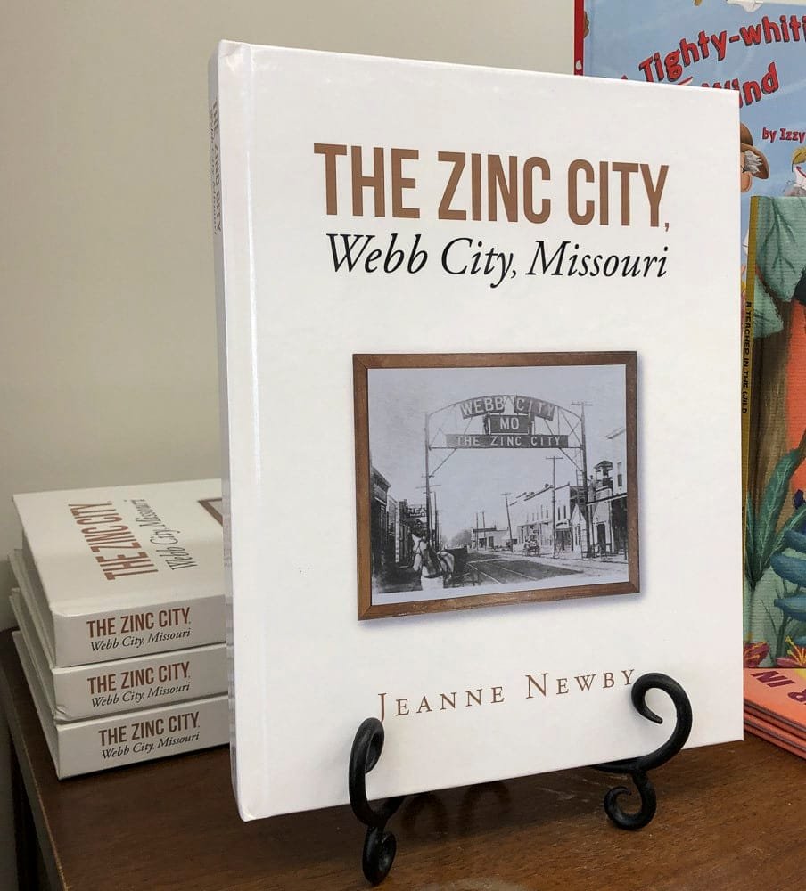
Jeanne’s new book, “The Zinc City, Webb City, Missouri” is now available at Webb City Chamber Office.